
72-Day Papua New Guinea, Indonesia, P
Seabourn · Seabourn Pursuit
Depart
Aug 26, 2027
Return
Nov 6, 2027
Port
Darwin, Australia
Nights
72 nights
At a glance
- Built
- 2023
- Tonnage
- 23000
- Cabins
- 132
- Crew
- 120
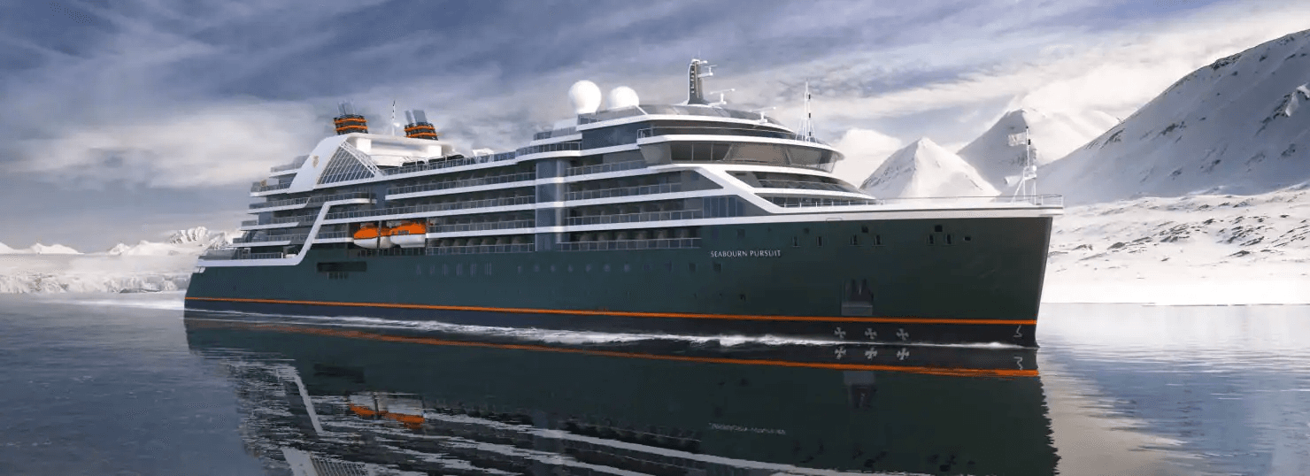
Construction for Seabourn Pursuit began in fall 2020 during a ceremony in San Giorgo di Nogare, Italy, and the build process is well underway. The ship is scheduled for delivery in 2023, with its sister ship, Seabourn Venture, slated for delivery in 2022. Seabourn Pursuit is the second Seabourn expedition ship slated to launch in 2023.
Ask our cruise specialists about cruise line loyalty benefits, status match options, drinks packages, gratuities and any current offers available on this sailing.
On board

Bowlounge

Colonnade
Constellationlounge

Discoverycenter

Expeditionlounge

Landing
Pursuit square
Itinerary
Cruise from Darwin, Australia to Ushuaia, Argentina
Day 1Cruise departs from Darwin, AustraliaAug 25, 2027
Despite its small size, Darwin is a modern, multi-cultural city, and its proximity to Asia makes it ideal for travel. Named after the famous scientist, Charles Darwin, the area was originally settled by the Larrakia Aboriginals. The Dutch arrived and mapped the land in the 1600s, followed by the British in 1939, when the town was given its English name. Darwin has a beautiful coastline, as well as numerous parks and gardens, making the city a top spot for outdoor activities.
Day 1Darwin, AustraliaAug 25, 2027 • Departs at: 5 pm
Despite its small size, Darwin is a modern, multi-cultural city, and its proximity to Asia makes it ideal for travel. Named after the famous scientist, Charles Darwin, the area was originally settled by the Larrakia Aboriginals. The Dutch arrived and mapped the land in the 1600s, followed by the British in 1939, when the town was given its English name. Darwin has a beautiful coastline, as well as numerous parks and gardens, making the city a top spot for outdoor activities.
Day 2At SeaAug 27, 2027
Day 3Ambon, IndonesiaAug 28, 2027 • Arrives at: 8 am • Departs at: 5 pm
See the Tiahahu Monument, a tribute to a young female Maluku freedom fighter, the Siwalima Museum’s ethnic arts and crafts, visit Soya Atas village, or the “Sacred Eels” of Waai.
Day 4At SeaAug 29, 2027
Day 5KokasAug 30, 2027 • Arrives at: 8 am • Departs at: 6 pm
Day 6Misool, Yapap LagoonAug 31, 2027 • Arrives at: 8 am • Departs at: 6 pm
Day 7Yenwaupnor, IndonesiaSep 1, 2027 • Arrives at: 4 am • Departs at: 11 am
Day 7Mansuar Island, Raja AmpatSep 1, 2027 • Arrives at: 1 pm • Departs at: 5:30 pm
Day 8Manokwari, IndonesiaSep 2, 2027 • Arrives at: 11 am • Departs at: 6 pm
Day 9Exploring Cenderawasih BaySep 3, 2027 • Arrives at: 8 am • Departs at: 5 pm
Day 10Exploring Cenderawasih BaySep 4, 2027 • Arrives at: 7 am • Departs at: 4 pm
Day 11JayapuraSep 5, 2027 • Arrives at: 10 pm • Departs at: 11 pm
Day 12VanimoSep 6, 2027 • Arrives at: 7 am • Departs at: 3 pm
Day 13At SeaSep 7, 2027
Day 14Garove Island, Papua New GuineaSep 8, 2027 • Arrives at: 8 am • Departs at: 4 pm
Day 15Duke of York Island, Papua New GuineaSep 9, 2027 • Arrives at: 8 am • Departs at: 12 pm
Day 15RabaulSep 9, 2027 • Arrives at: 1:30 pm • Departs at: 11:30 pm
Day 16At SeaSep 10, 2027
Day 17Ghizo Island, Solomon IslandsSep 11, 2027 • Arrives at: 8 am • Departs at: 3 pm
Ghizo Island, home to Gizo, the capital of the Western Province, Solomon Islands. The island is named after an infamous local head-hunter. It is located west of New Georgia and Kolombangara.
Day 18HoniaraSep 12, 2027 • Arrives at: 8 am • Departs at: 6 pm
The Solomon Islands is a sovereign nation consisting of multiple island groups, scattered in the South Pacific east of Papua New Guinea. Its capital is Honiara, on the island of Guadalcanal. Many of the outlying islands in the nation are relatively untouched, but Honiara is a busier hub of international commerce. The islands’ recent history is scarred by the desperate battles fought between the Japanese and American forces during World War II. In 1942, the Japanese launched their last great land offensive in the islands, which culminated in the Battle of Henderson Field fought at Honiara. Of the estimated 36,000 Japanese troops on Guadalcanal at the beginning, only 1,000 survived, the rest having either been killed directly, or succumbed to disease and starvation. Ghostly evidence of this horrific warfare dots the island, and it is memorialized at the American Memorial overlooking the town and at a smaller Solomons Peace Memorial erected by the Japanese outside the city. On a lighter…
Day 19At SeaSep 13, 2027
Day 20VanikoroSep 14, 2027 • Arrives at: 6 am • Departs at: 1 pm
Day 21Ambrym, VanuatuSep 15, 2027 • Arrives at: 9 am • Departs at: 4 pm
Day 22At SeaSep 16, 2027
Day 23Lautoka, FijiSep 17, 2027 • Arrives at: 7 am • Departs at: 5 pm
A major seaport, Fiji's second-largest city, Lautoka is the main center of the sugar and timber industries. Towering royal palms march in a long, orderly row from the main street to the harbor and into the heart of the city. Although Lautoka grew up around the Fijan village of Namoli, it is a very Indian town today.
Day 24Kadavu, FijiSep 18, 2027 • Arrives at: 7 am • Departs at: 5 pm
Day 25At SeaSep 19, 2027
Day 26Vavau, TongaSep 20, 2027 • Arrives at: 7 am • Departs at: 5 pm
Vavaʻu is the island group of one large island and 40 smaller ones in Tonga. It is part of Vavaʻu District which includes several other individual islands. According to tradition the Maui god finished up both Tongatapu and Vavaʻu, but put a little more effort into the former.
Day 27Nukupule Island, Ha'apai GroupSep 21, 2027 • Arrives at: 7 am • Departs at: 5 pm
Day 28At SeaSep 22, 2027
Day 29Apia, UpoloSep 23, 2027 • Arrives at: 7 am • Departs at: 5 pm
A total of sixteen islands comprise the Samoas, considered to be the heart of Polynesia. It was from these islands that early Polynesians sailed to populate other Pacific Islands. Today this chain of islands is divided into two political units - the U.S. Territory of American Samoa and the independent country of Western Samoa. Much of the charm of the Samoas lies in the simple village life and the friendly people, combined with a striking landscape of soaring mountain peaks, rugged coastlines, white sandy beaches and tropical rainforests rich in flowering plants. Western Samoa consists of a total of nine islands with the two main ones, Savi'i and Upolo, separated by a narrow strait. The country's capital Apia, resembling an old South Seas port during the early trading days, perches on the north coast of Upolo. Colonial-style wooden buildings and churches line the tree-shaded main street that curves around the harbor. The primary attractions include Parliament House, the village green,…
Day 29Cross International DatelineSep 23, 2027
Day 29At SeaSep 23, 2027
Day 30At SeaSep 24, 2027
Day 31AitutakiSep 25, 2027 • Arrives at: 8 am • Departs at: 5 pm
Day 32At SeaSep 26, 2027
Day 33Raiatea, Society Islands, French PolynesiaSep 27, 2027 • Arrives at: 9 am • Departs at: 5 pm
The second-largest of the Society Islands is practically twinned with its neighbor Taha’a. Actually they are connected by a reef in the same lagoon and may have been one island in the past. The main town, Uturoa is where most of the population lives. It’s lively, although no competition for Tahiti. Called the Sacred Island, Raiatea’s name means “bright sky,” and it was probably the first human community in the islands. The ancient sacred site of Taputapuatea is a UNESCO World Heritage Site, and may have been the place from which Polynesian migrations to Hawaii, the Cook Islands, New Zealand and the rest of the South Pacific started. Although less touristed than Tahiti, caring for visitors has grown in importance. Agriculture is mainly given over to coconuts, pineapples and vanilla. Vanilla orchids are hand-pollinated, since Raiatea has no insect pollinators for vanilla blossoms. South Seas pearls are farmed in the lagoon in various colors. A hike up Mt. Tapioi rewards with stunning vi…
Day 34Maroe Bay, HuahineSep 28, 2027 • Arrives at: 7 am • Departs at: 5 pm
Huahine is an island located among the Society Islands, in French Polynesia, an overseas territory of France in the Pacific Ocean. It is part of the Leeward Islands group. At the 2017 census it had a population of 6,075.
Day 35Papeete, French PolynesiaSep 29, 2027 • Arrives at: 7 am • Departs at: 5 pm
The islands of French Polynesia are acclaimed as the most beautiful in the South Pacific. Tahiti is the largest of the Polynesian islands and home to the capital city of Papeete, a delightful blend of cultures. Papeete, meaning the "water basket," was once a gathering place where Tahitians came to fill their calabashes with fresh water. Today, it is the gateway to the country, and boasts romantic resorts, fine dining, vibrant markets, pearl shops, and boutiques. Tahiti's mountainous interior is adorned with deep valleys and scenic waterfalls, while the rugged coastal lands are home to fields of tropical flowers, and glorious white and black sand beaches.
Day 36Anaa, French PolynesiaSep 30, 2027 • Arrives at: 12 pm • Departs at: 5 pm
Day 37TahaneaOct 1, 2027 • Arrives at: 7 am • Departs at: 5 pm
Day 38Fakarava, Tuamotu, French PolynesiaOct 2, 2027 • Arrives at: 6 am • Departs at: 7 am
The 77 Tuamotus, (the name means “Distant Islands” in Polynesian) comprise the largest chain of coral atolls on earth. They sprawl across the vast blue South Pacific Ocean encompassing an area the size of Western Europe. Atolls are literally the skeletal remains of coral reefs, forming rings of crushed coral sand surrounding a shallow central lagoon. The natural flora and fauna of the Oceanic realm is adapted to this environment, and Fakarava’s large lagoon is designated by UNESCO as a Biosphere Reserve. The people of Fakarava farm coconuts for copra on shore and pearls in the lagoons. They also host the travelers who flock here to bask on the beaches and snorkel or dive in the luxuriant coral gardens along the shore. At the long spit of Les Sables Roses, the pink blush of the sand reveals its coral origin. The sleepy towns of Rotoava and Tetamanu offer scant attractions for visitors, except for their distinctive rock lighthouses shaped like stepped pyramids. Tetamanu does boast a 19t…
Day 39At SeaOct 3, 2027
Day 40At SeaOct 4, 2027
Day 41Adamstown, Pitcairn IslandOct 5, 2027 • Arrives at: 7 am • Departs at: 3 pm
Adamstown is the capital of, and the only settlement on, the Pitcairn Islands.
Day 42Ducie IslandOct 6, 2027 • Arrives at: 11 am • Departs at: 5 pm
Day 43At SeaOct 7, 2027
Day 44At SeaOct 8, 2027
Day 45Easter Island, ChileOct 9, 2027 • Arrives at: 7 am
The southeastern-most point in the Polynesian Triangle, tiny Easter Island in the South Pacific is one of the most remote places on earth. Even more oddly, it belongs to Chile, which lies 3,700 miles away over the eastern horizon. In fact, a large slice of the island is Chile’s Rapa Nui National Park, preserving the sculptural heritage of the indigenous Rapa Nui people, whose ancestors carved the huge human effigies called moai that give the island its renown and earned it UNESCO World Heritage Site status. These stylized sculptures stand on the slopes of the island, gazing implacably out to sea, often on stone platforms called ahu. They were apparently carved between the 13th and 16th centuries, for reasons that are debated. But the enigmatic effigies, the dramatic volcanic landscape, the Rapa Nui people themselves and the sheer isolation of the island combine to draw visitors from every corner of the globe to this speck in the world’s largest ocean.
Day 46Easter Island, ChileOct 10, 2027 • Departs at: 6 pm
The southeastern-most point in the Polynesian Triangle, tiny Easter Island in the South Pacific is one of the most remote places on earth. Even more oddly, it belongs to Chile, which lies 3,700 miles away over the eastern horizon. In fact, a large slice of the island is Chile’s Rapa Nui National Park, preserving the sculptural heritage of the indigenous Rapa Nui people, whose ancestors carved the huge human effigies called moai that give the island its renown and earned it UNESCO World Heritage Site status. These stylized sculptures stand on the slopes of the island, gazing implacably out to sea, often on stone platforms called ahu. They were apparently carved between the 13th and 16th centuries, for reasons that are debated. But the enigmatic effigies, the dramatic volcanic landscape, the Rapa Nui people themselves and the sheer isolation of the island combine to draw visitors from every corner of the globe to this speck in the world’s largest ocean.
Day 47At SeaOct 11, 2027
Day 48At SeaOct 12, 2027
Day 49At SeaOct 13, 2027
Day 50At SeaOct 14, 2027
Day 51The Seabourn Juan Fernandez ExperienceOct 15, 2027 • Arrives at: 7 am • Departs at: 5 pm
Day 52The Seabourn Juan Fernandez ExperienceOct 16, 2027 • Arrives at: 7 am • Departs at: 5 pm
Day 53At SeaOct 17, 2027
Day 54San Antonio (Santiago), ChileOct 18, 2027 • Arrives at: 7 am • Departs at: 5 pm
This large, modern port serves Chile’s capital, Santiago, a city with Spanish colonial charm and a vivacious spirit. Encircled by the Andes and the Coastal Range, Santiago is centered around the Plaza de Armas, with several of the city’s landmarks: the 18th-century Metropolitan Cathedral the Palacio de la Real Audencia from 1808, the City Hall and the National Museum of History. North of San Antonio lie the picturesque old port and university town of Valparaíso and the colorful seaside resort of Viña del Mar. In between the coast and the capital are valleys filled with some of Chile’s most famous wineries, all inviting you to come and taste.
Day 55At SeaOct 19, 2027
Day 56Scenic Cruising Reloncavi SoundOct 20, 2027
Puerto Montt, in Chile’s Northern Patagonia Los Lagos region is set on the shores of a large bay identified as Reloncavi Sound. To the east looms Mt. Yate, a snowcapped, glaciated stratovolcano, and beyond that the cordillera of the Andes. The sound is punctuated by islands, the three largest being Tengio, Maillén and Huar. Two much larger islands, Puluqiui and Queulín, sprawl across the mouth of the sound, separating it from the Gulf of Ancud. The point where the Reloncavi Estuary empties into the sound is effectively where the Chilean Central Valley meets the Pacific Ocean. Salmon farms dimple the coves of the sound, and pods of orcas are sometimes seen. Near the sound on shore, Chile’s Alerce Andino National Park protects a vestigial forest of ancient alerce trees, similar to the huge sequoias found in North America.
Day 56Puerto Montt, ChileOct 20, 2027 • Arrives at: 10:30 am • Departs at: 6 pm
The lake country of southern Chile seems to be altogether another world from the deserts of the north. The Lake District is graced with spectacular scenery, including the magnificent snowcapped volcanic cone, Mt. Osorno. Puerto Montt serves as the principal port for this region and as a gateway for cruises southward into Chile's fjords.
Day 57Scenic Cruising Moraleda ChannelOct 21, 2027
The Moraleda Channel is a protected waterway running along the coast of Chile from the Gulf of Corcovado in the north to the Laguna San Rafael in the south. It separates the myriad mountainous islands of the Chonos Archipelago from the Chilean mainland. Like the Inside Passage on the Pacific coast of North America, the Moraleda Channel is a geological feature. Its course follows the geologic Liguiñe-Ofqui Fault on the eastern side of the islands, which are actually the peaks of the submerged Chilean Coastal Range.
Day 57Scenic Cruising Darwin ChannelOct 21, 2027
The Darwin Channel cuts through the elongated, mountainous islands of the Chonos Archipelago in Southern Chile, connecting the Pacific Ocean on the west with the Moraleda Channel running along the Chilean mainland. These forested islands, mostly uninhabited, are actually the peaks of the submerged Chilean Coastal Range. Darwin Channel is a westward continuation of the Aysén Fjord, connecting to the Pacific at Isquiliac Island, and opening at its eastern end into Darwin Bay. Being free of navigational hazards, it forms a preferred, scenic pathway for ships navigating in the area.
Day 58Scenic Cruising Baker ChannelOct 22, 2027
The Baker Channel is a large, multi-armed fjord that cuts from Tarn Bay in the Gulf of Penas some 75 miles into the Chilean mainland. It lies roughly halfway between the Northern and Southern Patagonian Ice Fields, and its southern arm culminates at the face of the Jorge Montt Glacier, which flows from the Southern ice field and frequently calves icebergs into the channel. The channel forms the northern boundary of Chile’s vast Bernardo O’Higgins National Park.
Day 58Caleta Tortel, ChileOct 22, 2027 • Arrives at: 10 am • Departs at: 6 pm
Day 58Transit The English NarrowsOct 22, 2027
On the long Messier Channel between the huge Wellington island and the Chilean mainland, the English Narrows is a natural, eight-mile obstacle consisting of a scattering of islands constricting the passage to a width of as little as 200 yards. It presents no hazard to a skilled navigator under most conditions, but at spring tides the current runs as much as six knots, and wind conditions may also make navigation risky. The narrows transit is a good time to be on deck, to keep an eye out for birds such as diving petrels or steamer ducks, and possibly the small, rare dolphins that are sometimes seen in remote areas like this.
Day 59Scenic Cruising Eyre FjordOct 23, 2027
Eyre Fjord penetrates the mainland of southern Chile from the Icy Channel about 20 miles to the broad face of the massive Pio XI glacier, also known as the Brüggen Glacier. It is the longest glacier in the Southern Hemisphere outside Antarctica, flowing some 40 miles from the Southern Patagonian Ice Field to the fjord. It is also one of the very few advancing glaciers on earth. The glacier face is located near a large eastern arm of Eyre Fjord called Exmouth Fjord.
Day 59Pio XI GlacierOct 23, 2027 • Arrives at: 8 am • Departs at: 1 pm
Day 59Scenic Cruising Wide ChannelOct 23, 2027
The Wide Channel is an inside passage along the coast of southern Chile. It separates the eastern lobe of the huge Wellington Island from the Chilean mainland, starting between Saumarez Island and Icy Channel in the north and opening into the Concepcion Channel in the south adjacent to the Bernardo O’Higgins National Park on the mainland Wilcock Peninsula. Surrounded by precipitous mountains, its shoreline on the mainland side is interrupted by two large fjords, the Europa and Penguin fjords. Join your expedition team members on deck or in an observation lounge for expert insights into the area.
Day 60Scenic Cruising Peel FjordOct 24, 2027
Cutting eastward from the Sarmiento Channel in Southern Chile, this fjord divides into three separate fjords, called Amalia, Asia and Calvo Fjords. Amalia leads to Amalia Glacier, the El Brujo Glacier is in Asia Fjord, and Calvo boasts several small glaciers of its own. The mainland to the east is all part of the huge Torres del Paine National Park. The area is a fascinating geological panorama, and your expedition team members will be available to interpret the sights, as well as identify wildlife spotted while cruising the scenic waterways.
Day 60Brujo GlacierOct 24, 2027 • Arrives at: 7 am • Departs at: 11 am
Day 60Scenic Cruising Smyth ChannelOct 24, 2027
The Smyth Channel is another of the spectacular waterways threading the maze of islands off the coast of extreme southern Chile. At its northern end, it briefly parallels the Sarmiento Channel, then veers southward opening into the Strait of Magellan. Dotted with myriad small islands and corrugated with countless narrow fjords and bays, it makes a mesmerizing panorama as your ship plies between the islands on one side and the immense Peninsula Muñoz-Gamero on the other. Members of your expedition team will be on deck and in lounges to offer insights into the wild, unspoiled terrain you are passing.
Day 61Strait of MagellanOct 25, 2027
The Strait of Magellan is a 350-mile/570 km channel separating the mainland of South America from the large Isla Grande de Tierra del Fuego and connecting the Atlantic and Pacific Oceans. It was first navigated by the explorer Ferdinand Magellan during his circumnavigation voyage in 1520. He named it the Strait of All Saints, because his transit started on November 1, All Saints Day. It was also Magellan who name the southern island Tierra del Fuego, after seeing the smokes from fires in the camps of the native Yahgan people, whom he named the Patagones, meaning “big feet,” and their land Patagonia. The strait is between two and 20 miles wide, and earned the nickname Dragon’s Tail among sailors, for its tortuous path. Along with the Beagle Channel, it was one of two protected channels for sailing between the oceans prior to the construction of the Panama Canal The third alternative was the notoriously turbulent open ocean Drake Passage beyond Cape Horn. There is one sizeable port city…
Day 61Punta Arenas, ChileOct 25, 2027 • Arrives at: 12 pm
Red roofs and smoking chimneys decorate the gently sloping hillsides of Punta Arenas (Sandy Point), the bustling center of one of the world's largest sheep farming areas. This pleasant community welcomes you with attractive parks and delightful Victorian architecture.
Day 62Punta Arenas, ChileOct 26, 2027 • Departs at: 6 pm
Red roofs and smoking chimneys decorate the gently sloping hillsides of Punta Arenas (Sandy Point), the bustling center of one of the world's largest sheep farming areas. This pleasant community welcomes you with attractive parks and delightful Victorian architecture.
Day 63At SeaOct 27, 2027
Day 64At SeaOct 28, 2027
Day 65The Seabourn Antarctic ExperienceOct 29, 2027 • Arrives at: 7 am • Departs at: 5 pm
Day 66The Seabourn Antarctic ExperienceOct 30, 2027 • Arrives at: 7 am • Departs at: 5 pm
Day 67The Seabourn Antarctic ExperienceOct 31, 2027 • Arrives at: 7 am • Departs at: 5 pm
Day 68The Seabourn Antarctic ExperienceNov 1, 2027 • Arrives at: 7 am • Departs at: 5 pm
Day 69The Seabourn Antarctic ExperienceNov 2, 2027 • Arrives at: 7 am • Departs at: 5 pm
Day 70At SeaNov 3, 2027
Day 71Ushuaia, ArgentinaNov 4, 2027 • Arrives at: 7 pm
The southernmost city in the world, Ushuaia is the capital of Argentine Tierra del Fuego and an important naval base boasting a strategic as well as a picturesque location on the shores of Ushuaia Bay and the Beagle Channel. This rustic coastal town is set among waterfalls, glaciers, snow-clad mountains and beech forests, and the nutrient-rich local waters abound with marine life. Though the houses here are painted warm, pastel colors, the weather is chilly year-round and winter sports such as downhill and cross-country skiing and skating are popular. Ushuaia's principal industries are raising sheep, logging, fishing and trapping. It became a boomtown with 30,000 residents in the late 1980's when the government sought to increase Argentina's presence near Antarctica by giving tax breaks to citizens who settled here.
Day 72Cruise returns to Ushuaia, ArgentinaNov 5, 2027
The southernmost city in the world, Ushuaia is the capital of Argentine Tierra del Fuego and an important naval base boasting a strategic as well as a picturesque location on the shores of Ushuaia Bay and the Beagle Channel. This rustic coastal town is set among waterfalls, glaciers, snow-clad mountains and beech forests, and the nutrient-rich local waters abound with marine life. Though the houses here are painted warm, pastel colors, the weather is chilly year-round and winter sports such as downhill and cross-country skiing and skating are popular. Ushuaia's principal industries are raising sheep, logging, fishing and trapping. It became a boomtown with 30,000 residents in the late 1980's when the government sought to increase Argentina's presence near Antarctica by giving tax breaks to citizens who settled here.
Cabin options
Compare the cabin types and onboard features shown for this sailing. Final price and availability are confirmed by our team when you inquire.
10 cabin grades listed for this sailing.
Next step
Cabin grades and prices
View every cabin grade and current availability on the next step.